


Longitude at sea: from compass to chronometer

Without longitude to steer their course, far too many sailors were lost at sea. It took centuries, and many ingenious inventions, before they were able to find the route to India or simply the way home.
For as long as sailors stayed within sight of the coast for their voyages and to trade fabrics, spices, metals and ceramics, they had no need to know the exact time in order to plot their position. However, with pioneers such as Christopher Columbus who set sail in search of the shortest route to India, Vasco de Gama who kept to the more traditional route, and Magellan who was first to circumnavigate the globe, the oceans revealed themselves to be a vast and uncharted expanse with no point of reference save latitude, measured since Antiquity using a quadrant, a quarter-circle in wood or bronze with graduated degrees around its limb. Crews would “dead reckon”, attempting to plot their position by observing the stars and the direction of the currents and winds. Time and again these empirical and imprecise methods ended in dramatic shipwrecks.
Scholars and sovereigns
The sea and, lying beyond its many perils, new lands would become the scene of economic and political rivalry from the fifteenth century. Ships set sail not to accomplish an exploit: instead their captains were acting on command of their sovereign, who invested money in these expeditions on the understanding they would bring rich returns. A new maritime route had to bring wealth, power and prestige to the royal commander of these fleets, which founded trading posts and anchoring points all along their route. And given the amounts invested, these routes could not be left to chance. The damage inflicted by storms and, later, battles between rival fleets was already costly enough. Thus scholars set to work developing reliable instruments of measure (geolocation, as we would say today).
By the early seventeenth century, scholars had put forward various solutions based on the distance between the Earth and the Moon or the Sun at its zenith. A 1765 account noted that the first method took “no more than four hours” to find a position at sea to within one degree (which at the equator can still be one hundred and ten kilometres out). The second method determines the exact longitude by comparing local noon with an hour of reference. Ships still use this method today, even though they are kept constantly informed of their exact position.
The Longitude Act inspires progress
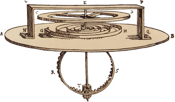
The best way to measure longitude at sea was to have a clock onboard (until then, ships sailed with a sundial mounted on a compass). As of 1658, the Dutch physicist and astronomer Christiaan Huygens looked into ways to adapt a pendulum clock for use at sea. In 1675 he invented the balance spring which resulted in substantially greater accuracy. Four years later he abandoned pendulum clocks to concentrate on timepieces with a balance and spring, the ancestors of marine chronometers. The idea was inspired but trials proved disappointing, as temperature changes greatly affected the elasticity of the spring.
The Observatoire de Paris was founded in 1667 with the primary vocation of studying longitudes. The Royal Observatory at Greenwich was founded in 1675. In 1707, Britain suffered a humiliating disaster when four British men o’ war needlessly foundered off the Cornish coast, costing the lives of some two thousand men. Following this, Parliament passed the Longitude Act which offered phenomenal rewards to whomever found a reliable way to determine longitude to within less than one degree. The English and the French led the field in this race. Numerous master watchmakers would be instrumental in developing and perfecting the marine chronometer, all working towards a triple objective: invent an escapement that would allow the balance to oscillate freely without being disturbed by residual friction from the gears; discover a means of compensating for temperature differences, and “immunise” the chronometer against the rise-and-fall motion of the ship.
Timekeeping at sea
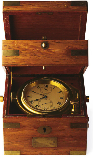
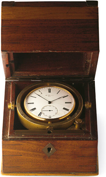
In 1754 Frenchman Pierre Le Roy devised a “detent escapement” that was suitable for a marine chronometer. In 1766 he produced the ultimate prototype, which included a system of temperature compensation. Chronometers such as this were built to strict specifications by workshops including A. Lange & Söhne, Henri Perregaux, Constant Girard-Perregaux and Vacheron & Constantin. In 1844 Antoine LeCoultre created the first instrument to measure a micron or one thousandth of a millimetre. It became the standard measure for the production of pinions for marine chronometers for more than half a century. Meanwhile, in England, John Arnold filed patents for his discoveries, including the cylindrical spring. Girard-Perregaux would choose this invention for its 1880 precision tourbillon under two gold bridges.
Surprisingly, the chronometer was slow to seduce as few sailors grasped navigational theory and the rare master watchmakers with the capacity to produce accurate chronometers did so at dissuasive prices. Only captains who navigated in the polar or as yet uncharted regions were quick to rally to this invention.
This article draws on the text written by Dominique Fléchon, fine watchmaking expert and historian, for the Salon International de la Haute Horlogerie (SIHH) 2006.